
 …and more ice.
 We woke up in Lead to find about four inches of snow on the ground, and a weather forecast predicting much more of the same throughout the weekend. We had planned to head for the Badlands and Wounded Knee and the Pine Ridge Reservation that day.
 I was in the Badlands last year, on a trip across the country (in the other direction) with my mom. I might have mentioned this before, but for her sixtieth birthday she was going to treat herself with a roadtrip from Seattle to Brooklyn. Having just gone freelance, laptop in hand, I flew out and went with her.
Some of our favorite parts of that trip were the things we saw in the Badlands and on the Pine Ridge Reservation in South Dakota.
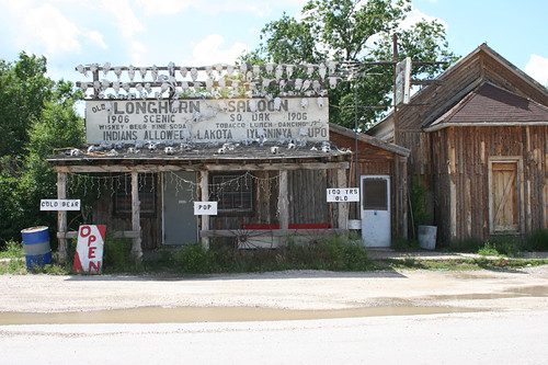 There are two units in the Badlands—the Northern unit and the Southern unit. In between the two, there's a town called Scenic, which still has an old stone jail and some old buildings, like the one above.
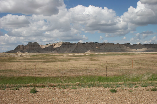 The Southern unit is known as the Stronghold, because the Lakota would go there when the cavalry was pursuing them. Custer called the Badlands (though I'm pretty sure he was talking about North Dakota) "hell without the fire." You could easily get lost in them if you don't know your way around.
 As you drive southwest from the Stronghold, you enter the Pine Ridge Reservation. I studied federal Indian policy as a big part of my undergrad history major and was excited to be there—as ironic as that might sound, with Pine Ridge being the poorest county in the entire country. In a previous post about this current roadtrip, I mentioned the feeling that in the West, history is all around you.
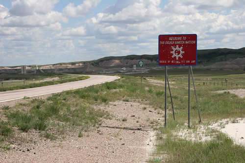 That is true everywhere of course, but places like Pine Ridge drive the point home. In 1887 Congress passed the Dawes Act, which split much reservation land into parcels individually owned by tribal members. Under the guise of assimilating Indians into the larger society, the Dawes Act actually just made it easier to dupe people out of their land. As you drive into the res you see a ton of signs marking who owns what allotment. In speaking with people, you quickly realize that it's common to own multiple tiny parcels of land spread across a huge area—sometimes more than one state—the ragtag remnants of whatever parts of allotments weren't sold off to whites. One guy told me he had land in South Dakota, North Dakota, Nebraska, and Minnesota, some of it as small as several square yards.
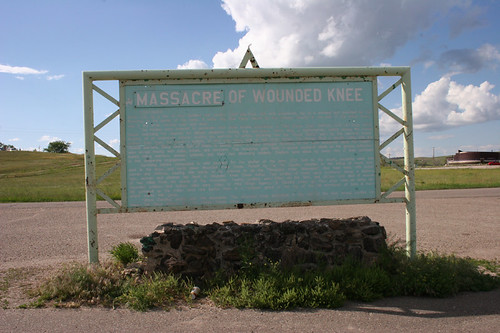 A little farther down the road, you reach the memorial of the Wounded Knee Massacre. You can read all about that elsewhere (a good place to start is Dee Brown's 1970 book Bury My Heart at Wounded Knee), but essentially it was the last major armed conflict between Indians and the US Army. The 7th Cavalry was disarming a large group of ghost dancers, and when one demanded payment in exchange for his rifle, the cavalry opened up with hotchkiss guns, mowing down more than 300 men, women, and children as they attempted to flee. It used to be called a "battle" but in 1990 the government issued a "statement of deep regret" and a board reading "massacre" was nailed up over it. No formal apology, no polished monument.
 So, uh, not to bring the room down or anything, but that's there, and I think it's worth seeing. People leave sage, tobacco, candies, bullet shells and other offerings at the grave marker. The rest of the reservation is interesting to see as well—many of the roads marked as major are actually unpaved, and fun to explore.
 But back to the current roadtrip. Emily and I decided that, as much as we wanted to go, braving the Badlands and the back roads of Pine Ridge in the coming blizzard was not worth it, and quickly re-tooled our plans. We drove south out of Lead and saw a completely fogged-in Mount Rushmore.
 There are often mountain goats walking around down there, and this trip didn't disappoint. (And the mountain itself is fairly overrated, so no big whoop that we couldn't see it.) We headed north on scenic highway 14A, along Spearfish Creek and on to Wyoming for a look at Devil's Tower National Monument.
 Foggy too, but still worth it. One of the major characteristics of this trip has been getting the national park system to ourselves. We walked the 1.3 mile trail around the tower with no interference whatsoever.
 As we drove west from there, the weather reports were getting more and more ominous. I didn't take many photos, but I did snap this one—I think it was in Moorcroft. We've seen a few bars like this, with brands all over the side of them. They almost seem like gang tags.
 We had planned to go through the Bighorn Mountains and on to Yellowstone, but I-90 itself was icing up; we figured the smaller roads would be worse, and we wouldn't be able to see much anyway. So we stopped to throw down at a Taco Bell in Gillette, and as it started to get dark, we buckled in for a slog toward as far as we could get in Montana.


No comments:
Post a Comment