Monday, October 13, 2008

"What'chya need ta do is git yer compost co-rrect"

We pulled into Missoula and found a room at the Bel-Aire just as the sun was going down, and headed for the Missoula Club (they call it the Mo Club), which has been around forever and has the city's best burger. I was there last year on my mom's 60th birthday:

Bill Clinton went to the Mo last time he was in town, and I had heard that Obama was there too, but our bartender said he wasn't. Anyway, it's a great spot, an absolute necessity if you're ever in Missoula.

The other one is the Oxford, around the corner and up the street. The Mo club is kind of college-centric (though not in an annoying way, because it's so old, it's an institution to the whole community), but the Ox is more of an old locals bar. They have this amazing collection of rifles above the bar, some pool tables, and a card game going by the front door.

We got into a conversation with a girl who lives off the grid with her husband out in the hills, and stops by the Ox when she's in town. She had moved from Tennessee and was telling us that because the ground is so rocky in the mountains, it took her a long time to learn to get her compost and soil mulching just right, but now she has a big garden, and they hunt, and only occasionally go to the grocery store. There was also this dude at the bar who had served two tours in Vietnam (yes – he was in the shit), had beaten what appeared to be a pretty severe meth addiction, and was now doing pretty well in construction. Another guy came by selling artwork, and we bought this little piece for $5. You can check out his website at petedaviesart.com.

So anyway, it was your regular mix of local peeps and we were having a good time, until this dude with a McCain/Palin baseball cap walked in. The mulch girl said "I like your hat," and when I asked her if she was serious, she said she was not a Republican, but that she was against Obama. We all got into a conversation about it, and the Nam/meth dude got really agitated, basically telling me that saying I was for Obama was tantamount to challenging him to a duel, i.e., he was about to attempt to kick my ass. It was weird. We couldn't really reason with them, and it was strange to go from being fast friends to being at odds faster. Once we steered away from that topic we were able to smooth things out, but it was kind of annoying, so we left after awhile.

It's been weird going across the country and finding that some people you'd think would be for Obama – who would benefit from being for Obama – are stuck in a rut, believing all the same old lies and sticking with the Republicans through and through. You see it on TV and you read about it, but it's a whole other experience to sit and talk with people like that – people who can't or won't explain their views, but just know they hate Obama. So much of this country is way behind the curve, period. And I know I'm preaching to the choir, and this is maybe not even worth writing about, but here it is.

As we were leaving, Pete Davies walked by and we thanked him again for the artwork. He said it was an outlet, a way for him to put the weird things in his head down on paper. When I told him he was probably the sanest person I had talked to all night, he leaned in close, looked around the room cautiously, and quietly replied, "I'm a skitzophrenic." It was a strange night.

Sunday, October 12, 2008

Butte in the Meantime

On our way to Missoula we stopped through Butte, Montana. At its peak as a copper mining boomtown, Butte was the largest city between Seattle and Minneapolis, with around 100,000 people living there. Now the population is about 30,000, but signs of previous glory are everywhere – Butte has the largest historic landmark district in the country.


Butte's initial boom owed to a huge influx of Irish workers. I can't remember the guy's name but someone put ads in the New York papers that Irish could find jobs and land in Butte, and since things weren't going so well in New York at the time, many came west.

The Saint Patrick's Day parade here is one of the biggest in the country, and the University of Montana (at Missoula) has the only Irish Studies program in the United States. Many people in Butte still have a slight Irish accent, carried down since those early frontier days.

These blue sky pictures were taken on a previous trip – it's always a good idea to stop through Butte.

Up next: Missoula.

Saturday, October 11, 2008

Staying Frosty

Last night's drive was one of the more surreal experiences of my life. It was pitch black – Wyoming and Montana don't have lights on the freeway except near towns, and there aren't many towns – and we were experiencing the genesis of a serious blizzard. Half the time, with our headlights shining at blackness and sideways snowflakes, it felt as if the car was not moving at all, but caught in some kind of bucking light show. Other times, on hills I guess, and on bridges, which really do freeze before everything else, it was like we were making the jump to light speed and everything was moving way too fast. I was glad, not to mention thankful for my life, when we finally pulled in to Bozeman, Montana, found a hotel, and collapsed with some much-needed MSNBC vs. Bravo action. I slept hard – the kind of hard where you wake up in the middle of the night and don't know where you are, and don't care.

This morning we woke up and it was still cold as hell, and the world (i.e. the parking lot) was covered with ice, but it wasn't snowing too hard. We decided we would look around Bozeman a little before heading to Butte and then Missoula.

I found some great records (I'm overdue on posting new acquisitions – those are coming soon) and Emily found good fashion photography book, and a shirt and belt at Salvation Army (ditto on that). And there are a lot of good neon signs.

I wouldn't call Bozeman a destination (unless you're there to ski or pursue some other outdoor activity) but if you ever find yourself here, as we did, feel glad. Just like Missoula and Bellingham and Ellensburg and Moscow, it's a frontier college town with a solid weekend's worth of fun stuff to do.

Next up: Butte.

Ice Road Truckers

…and more ice.

We woke up in Lead to find about four inches of snow on the ground, and a weather forecast predicting much more of the same throughout the weekend. We had planned to head for the Badlands and Wounded Knee and the Pine Ridge Reservation that day.

I was in the Badlands last year, on a trip across the country (in the other direction) with my mom. I might have mentioned this before, but for her sixtieth birthday she was going to treat herself with a roadtrip from Seattle to Brooklyn. Having just gone freelance, laptop in hand, I flew out and went with her.

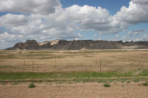
Some of our favorite parts of that trip were the things we saw in the Badlands and on the Pine Ridge Reservation in South Dakota.

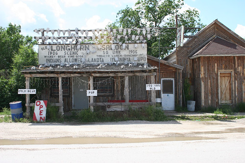
There are two units in the Badlands—the Northern unit and the Southern unit. In between the two, there's a town called Scenic, which still has an old stone jail and some old buildings, like the one above.

The Southern unit is known as the Stronghold, because the Lakota would go there when the cavalry was pursuing them. Custer called the Badlands (though I'm pretty sure he was talking about North Dakota) "hell without the fire." You could easily get lost in them if you don't know your way around.

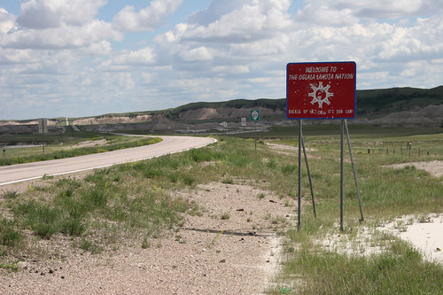
As you drive southwest from the Stronghold, you enter the Pine Ridge Reservation. I studied federal Indian policy as a big part of my undergrad history major and was excited to be there—as ironic as that might sound, with Pine Ridge being the poorest county in the entire country. In a previous post about this current roadtrip, I mentioned the feeling that in the West, history is all around you.

That is true everywhere of course, but places like Pine Ridge drive the point home. In 1887 Congress passed the Dawes Act, which split much reservation land into parcels individually owned by tribal members. Under the guise of assimilating Indians into the larger society, the Dawes Act actually just made it easier to dupe people out of their land. As you drive into the res you see a ton of signs marking who owns what allotment. In speaking with people, you quickly realize that it's common to own multiple tiny parcels of land spread across a huge area—sometimes more than one state—the ragtag remnants of whatever parts of allotments weren't sold off to whites. One guy told me he had land in South Dakota, North Dakota, Nebraska, and Minnesota, some of it as small as several square yards.

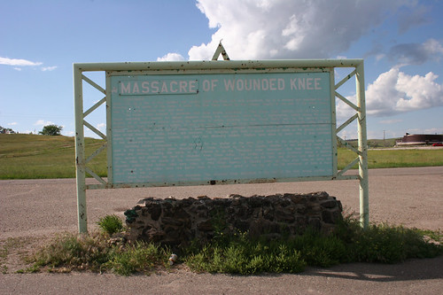
A little farther down the road, you reach the memorial of the Wounded Knee Massacre. You can read all about that elsewhere (a good place to start is Dee Brown's 1970 book Bury My Heart at Wounded Knee), but essentially it was the last major armed conflict between Indians and the US Army. The 7th Cavalry was disarming a large group of ghost dancers, and when one demanded payment in exchange for his rifle, the cavalry opened up with hotchkiss guns, mowing down more than 300 men, women, and children as they attempted to flee. It used to be called a "battle" but in 1990 the government issued a "statement of deep regret" and a board reading "massacre" was nailed up over it. No formal apology, no polished monument.

So, uh, not to bring the room down or anything, but that's there, and I think it's worth seeing. People leave sage, tobacco, candies, bullet shells and other offerings at the grave marker. The rest of the reservation is interesting to see as well—many of the roads marked as major are actually unpaved, and fun to explore.

But back to the current roadtrip. Emily and I decided that, as much as we wanted to go, braving the Badlands and the back roads of Pine Ridge in the coming blizzard was not worth it, and quickly re-tooled our plans. We drove south out of Lead and saw a completely fogged-in Mount Rushmore.

There are often mountain goats walking around down there, and this trip didn't disappoint. (And the mountain itself is fairly overrated, so no big whoop that we couldn't see it.) We headed north on scenic highway 14A, along Spearfish Creek and on to Wyoming for a look at Devil's Tower National Monument.

Foggy too, but still worth it. One of the major characteristics of this trip has been getting the national park system to ourselves. We walked the 1.3 mile trail around the tower with no interference whatsoever.

As we drove west from there, the weather reports were getting more and more ominous. I didn't take many photos, but I did snap this one—I think it was in Moorcroft. We've seen a few bars like this, with brands all over the side of them. They almost seem like gang tags.

We had planned to go through the Bighorn Mountains and on to Yellowstone, but I-90 itself was icing up; we figured the smaller roads would be worse, and we wouldn't be able to see much anyway. So we stopped to throw down at a Taco Bell in Gillette, and as it started to get dark, we buckled in for a slog toward as far as we could get in Montana.

Friday, October 10, 2008

The Hills

We ended up in Lead, South Dakota, staying at the Palace Express. We both agreed it's our second favorite hotel so far, after the one in Detroit.

The columns in the photo above have these smiling bald eagles on them.

We went to a couple bars and it's a pretty happening small town scene. Lead is in the middle of the Black Hills – the next town over from Deadwood, but without all the tourist traps. It's in a ravine, with the business district primarily in the bottom, and houses on the sides. The residential neighborhoods remind me a little of Aberdeen or Kalama.

When we headed back to the Palace, the snow was really starting to fall.

Thursday, October 9, 2008

On a Plain

.
After Fargo we drove across the Great Plains toward Theodore Roosevelt National Park. These plains are called Great not because they are better than good, which is debatable, but because they are really, really big. They just go and go. There are a few things to see a long the way but mostly it's just plains.

Valley City, ND

Golden Valley, ND

And, finally, Theodore Roosevelt National Park, on the western edge of the state. This guy was milling around the parking lot waiting to greet us when we got there.

This is Roosevelt's cabin in Medora, ND, where he lived for some time many years before he was President. The small museum they have set up about Roosevelt's time in North Dakota is really informative and well designed – being there made me want to learn more about him. He was once shot while giving a campaign speech, and insisted on finishing the speech before allowing a doctor to treat him.

His namesake park is breathtakingly beautiful. It's not so much grassland, as I'd thought, but a long corridor of northern badlands along the Little Missouri River. It's hard to describe the feeling of exhilaration I sometimes feel in the West – the landscape is so big and spectacular, and you can feel the history around you. We camped right on the river flat, once again with the whole place to ourselves.

On the entire trip, it was only our second night of clear skies. The moon was so bright we almost didn't need our lantern, and the stars were still spectacular. It was well below freezing and we huddled around a little fire.

The next morning I woke up to find that the tent was covered in a layer of icey dew.

I made a big pot of coffee and sat at the picnic table reading as the sun came up and lit the hills on the other side of the river.

Big yellow leaves were falling off the cottonwood trees, and other than the noise they were making and a train way off in the distance, it was totally quiet.

Well, these guys were making some noise too.

There weren't many prairie dogs by the river, but when we went up and over the hill toward Medora, there was a huge village. I had seen them in Yellowstone and the Bighorn Mountains last year but they were tiny – more like chipmunks. These plains dwellers were much bigger and reminded us of Littlejeans.

We would have liked to stay another day, but with snow in the forecast we decided we'd better take off for South Dakota. After sandwiches and coffee at the Iron Horse Saloon, we drove out through the Little Missouri National Grasslands, headed for the Black Hills.